23 Apr 2018

Helvellyn by Swirral and Striding Edges, 28th March 2018

I seem to wind up hitting Helvellyn on about 50% of my Lake District excursions. What can I say but it's a fabulous mountain!  It's crazy to think that three weeks ago when I did this there were still some proper winter conditions to contend with. I think things are looking more Spring-like on the high fells for the most part now.

Previous trips to Helvellyn have been in good weather and I wanted to try it on a gloomier day. I also wanted to make the most of the free parking in Glenridding, before the restrictions come into force after Good Friday!

I started out on the track up Glenridding, for the most part into a mild headwind with drizzly rain, or rainy drizzle depending on one's perspective.

Looking back along Glenridding

I felt quite 'cozy' in my waterproofs, and felt a repressed optimism as I gained towards Red Tarn.  The drizzle ebbed and abated, and occasionally a bit of blue sky could be spotted.  I had picked a day with a relatively low wind forecast as I didn't fancy being perched on the edges in high gusts! I was pleased to feel the conditions were in line with the meteorological predictions.

Catsty Cam had a delightful 'sugar-dusting' of new snow
Looking back

As the path wound up between Red Tarn and Catsty Cam I climbed into the clouds and onto a frosty looking Swirral Edge.  I donned the crampons, in retrospect perhaps sooner than needed. I didn't want to slip on potentially icy rocks. I took as adventurous a line as feasible, sticking to the crest as much as possible, and thoroughly enjoyed the steady push up the edge.  The exit to the summit plateau was guarded by a steep bank of rock hard, icy snow. There were no steps cut in and no chance of traction by kicking boots in here as the snow was too hard. I front pointed up with the crampons, with ice-axe in hand to self-belay. I felt a buzz on reaching the top of this steep section, knowing all difficulties were now overcome and all that remained was a brief, straightforward saunter to the summit.
  
Looking back over the exit of Swirral Edge from the top
This cairn marks the edge
A wintery looking cross shelter with the summit behind

I took a summit refreshment break; and turned my attention towards Striding Edge, my next objective. I was a little apprehensive about one section on the initial descent down, but on reaching it everything was straightforward enough, and I adhered to the crest more than I ever have along the length of the ridge, it was a blast!

Looking down on Striding Edge
Looking back up the steep top-end of Striding Edge
Striding Edge is a magnificent adventure in the mist

On reaching the memorial and High-Spying-How, marking the end of the serious scrambling, I felt sad to think of Winter coming to it's close. This year I invested in an ice-axe and crampons, and put a lot of time and work into learning the ropes of winter hillwalking. Proficiency moving and scrambling in crampons comes with time for sure. I am pleased with how far I have come. I look forward though to the longer Summer days and the opportunity to ditch the extra weight in equipment and increase the mileages. So it's goodbye for now Winter!

Looking down from Birkhouse Moor towards Ullswater

I ran into a father and son team who had wild-camped by Red Tarn (they were braver than me) and enjoyed chatting on the stretch from Hole in't Wall to Birkhouse Moor where we parted ways. I love meeting people on the hills.

Place Fell presides over the lake
Looking across Glenridding

It was a perfect morning out for me, just right given the ongoing precipitation, I wouldn't want to be out all day in those conditions! I made my way home for a well deserved early bath.

22 Apr 2018

Great Whernside


I have a serious backlog of rambly adventures to write about. This is almost a month ago, on 24th March 2018.

Great Whernside direct from Kettelwell and back is a lovely half-day's walk. There are longer variations but I had a limited time window for this one.

The route straight up the valley of Douber Gill Beck is so beautiful with sustained interest
The valley is quiet compared to the main route on the hillside to the left
It's a heavenly place to pass through
Looking up Hag Dike Gill Beck
As you reach the end of the valley the path fades away and the valley sides become steeper at the t junction convergence of Dowber Gill Wham and Hag Dike Gill Beck. I decided it was sensible to climb up along the banks to easier terrain, following the line of Hag Dike Gill Beck as it leads a path towards the summit.
looking back

The day's first encounter with snow
A wreckage of some sort! I'm not sure what the story was here!
 As I topped out there was the faintest spot of rain and I felt the chill in the wind so added a layer as I ate my sandwich and took in the views. I love the scope of the views available from this mountain, how you can look over East to the Moors, West and North to the Dales, and South over all of Yorkshire.  The view South is better from the far end of the ridge, not the summit.

There was a brief bank of snow, about 20 feet or so, guarding the top ridge. I used a shortened walking pole as a make-shift ice axe just in case I lost footing but the snow whilst consolidated was relatively soft and easily to cross.
Looking West
Summit Cairn

Trig point
 For my descent I tried the regular, popular path, and met various people coming up and down including a large walking group.  I'm not being funny but of all my experiences on Great Whernside to-date this was the least favorable. Pretty much any trackless line of ascent or descent would be a less boggy option than this path of doom!

Lovely views but the path is trashed
On reaching the hostel at Hag Dyke it was a little strange to suddenly walk straight into what felt like a bustling schoolyard with a ream of young kids playing out.  Passing by into calmer lands the path becomes better and a pleasant, gentle, grassy descent ensues back to Kettlewell.
Looking back up
Descending into Kettlewell
In an act of cheeky trespassing, I kept to the ridge here instead of sticking to the path on my right!
A lovely, if fleeting visit to my nearest mountain. Always a pleasure and i'm sure I'll return again soon. I hear the Wharfedale Three Peaks calling me in the Summer!

Y Garn

Wednesday 21st March and it was my final day in Snowdonia. I set off under gloomy skies at sunrise to scale Y Garn, taking the relatively straightforward path up along the North-East ridge.

The path to Y Garn starts out through a narrow canyon
The rising Sun over Tryfan created an incredible light show
Looking across Llyn Idwal to the Eastern Glyderau
Pen Yr Ole Wen resides across the Ogwen valley
I ascended at a steady pace as I was feeling the fatigue from the two preceding days of extensive hillwalking and scrambling.  As I ascended I slowly let go of my more ambitious plan of traversing over to Foel Goch and back via Y Llymllwyd. Not only was I tired but as I peered over to try and spot the route down from the ridge up Y Garn I couldn't spot it and I was not in the mood for an off-path descent down steep terrain. Reflecting back on satellite images there is a path which looks easy to follow so I perhaps regret my chickening out in hindsight. But until next time...

Occasional breaks in the cloud at Y Garn summit showed magnificent views of Glyder Fawr and Fach but the clag resumed in before I could photograph the Snowdon range to the West.
The last couple of hundred feet of Y Garn were in clag mostly. The last few metres at the top of the ridge were in winter condition, and whilst it's not too steep a slip could lead to something more serious if not arrested so I put the ice-axe in hand to self-belay over these few metres.

Whilst sat at the top enjoying a sandwich I looked up to see that the clag had cleared! I started taking photos but I only caught a glimpse of the Snowdon range to the West before it rolled in again, at least on that side.  The presence of mist fortified my decision to just head back down so I made my way towards Llyn Cewn and the top of the Devil's Kitchen path.

Llyn Cewn nestles below the convex slopes of Glyder Fawr
20 minutes after I vacated the summit of Y Garn, the cloud cleared. Sod's law.
As I descended it was still mid-morning and the general direction of pedestrian traffic on the Devil's Kitchen path was up, not down.  If I had set off just half an hour later I could have had much better views and would maybe have gone for a longer day. Rain was forecast for early Afternoon though.

Looking back up
Llyn Idwal
I met a goat on the path by the lake
Looking back up at Y Garn
On rocking back up at the Pen Y Benglog car park I felt glad not to be faced with the rain that was already being heralded by the greying sky. I gave my fond farewells to the Ogwen Valley, until again.

10 Apr 2018

Tryfan, False Gribin, Glyder Fawr

20th March 2018, the second of three days in Snowdonia, I set off on foot from the Idwal Cottage hostel where I was staying to a chilly but magnificent morning with the sun rising along the Ogwen Valley and behind Tryfan.

First steps
Looking over to Pen yr Ole Wen
I walked along the A5, then instead of taking the well established path up along the wall to Milestone Buttress, I took the more adventureous route starting from the layby/car park.  The snow obscured what there was of a path and I enjoyed working my way up the boulders.  It probably takes a little longer to negotiate this route but I had plenty of time.

looking up, Milestone Buttress on the right
Looking back over Llyn Ogwen
I didn't take any more photos on the way up Tryfan. It was my second time up there and I was endeavouring not to repeat the same I made on my first ascent, which was just back in February of this year.  This time, whilst there was a scattering of snow it was fresh and powdery in the most part, I didn't encounter hard ice and didn't need the crampons and ice axe as I was getting good traction with my hands and feet.
I didn't take any photos on the way up and I think this reflects on the level of my concentration -  my phone went into my backpack to avoid damage from rocky terrain, and I forgot all about it!
I was determined not to turn right too soon when ascending up around the North Ridge from Milestone Buttress, last time I wound myself up in steep cliffy terrain and had to think and find my way out of a grim situation. I still managed to turn too soon though, despite this time following  an obvious thoroughfare with polished rock and crampon scrapes it lead to a line which was a bit beyond me. After some pondering, swallowing pride, downclimbing and backtracking I was back underway. You can go wrong on the first section of Tryfan approaching the North Ridge from the West... I have 2 out of 2 times now. I was determined not to feel shaken and beat by the mountain on reaching the top this time, and this wasn't the start I wanted.
So onward, with pleasant scrambling and no serious difficulties. I passed the 'fake cannon', then eventually the cannon, onwards and upwards. Tryfan is very much a 'pick your own route' kind of mountain, which is awesome and frightening depending on where it takes you. I really enjoyed working my way up the rocky nose of the ridge. Eventually the North Tower loomed above.
'This is where many people become unstuck' - the advice from the BMC website echoed again in my mind. Last time I had a real nightmare here. This time I knew where to go, up the nose, left around the very top, drop into the notch at Nor Nor Gully and out the top. I got paranoid that I was on the wrong track about half way up and made my way back down, only to wind up back on the exact same route! Once I found the drop-down into Nor-Nor Gully I felt relief knowing all the serious challenges were behind. I scrambled on eventually reaching the summit, where I stopped for a well earned sandwich, meeting a couple of fellas who were heading back down via a snowy gully on the West side which they had come up and said 'wasn't that bad' which I guess is open to interperetation.
At least I reached the summit for the most part unshaken and ready for more, I was hoping to feel like I had mastered this beast, alas some more experience still required!

The view from the top was lovely
Looking South
Adam left, Eve right
I didn't jump between the monoliths. I'm saving that one for another day...
I progressed onwards down the South Ridge, which is by far an easier route than the North Ridge, said hi to some passers by and reached Bwlch Tryfan.  I stuck to the plan and turned West following the path down to Llyn Bochlwyd. A visual evaluation of Bristly Ridge affirmed that I wasn't ready for it, at least not in the icy conditions. It sits higher up than the bulk of Tryfan and as such was looking rather wintery...
On reaching Llyn Bochlwyd I took another comfort break then skirted around to the base of The False Gribin.
False Gribin centre-left, the not-so fales Gribin runs along the right
 The scambling ascent on False Gribin was thoroughly enjoyable, there was a real off-piste vibe and whilst there are some steeper sections nothing felt overbearing and I think any real obstacles are quite avoidable. Reflecting back if I do it again (which I will) I will probably take some of the bolder lines.

Looking back to Tryfan from the top of False Gribin
Llyn Bochlwyd in the foreground, Llyn Ogwen in the background
Looking down the Ogwen Valley towards Bethesda
Castell y Gwynt towers above
The False Gribin flows directly into the top section of Y Gribin once you reach the meeting point of the ridges. I have previously ascended via scrambly path to the West of the ridge, primarily due to a strong Easterly wind making the ridge crest seem foolish. Being blessed this time with a lovely still day, it would have been a cop out not to do the crest. So I did and I'm so glad I did, I had a fantastic time and it was truly the highlight of the day! there are some lovely exposed sections if you want them. There's a magnificent bit near the end where you traverse up and left onto a slope which just has a sheer death drop directly below, it really is awesome!

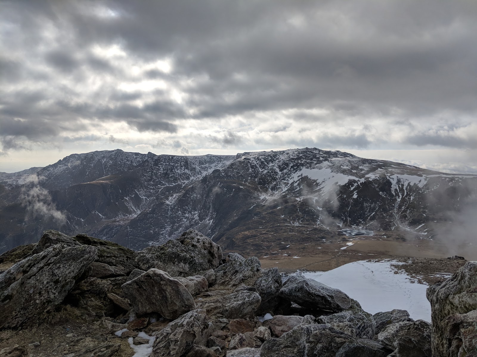
Looking over to the next objective, Glyder Fawr
Glyder Fawer is the highest of the Glyderau, and it is crowned with crazy rock formations which make it look so majestic. I think it's underrated.

Looking over to Snowdon from the summit of Glyder Fawr
North-West, Y Garn in the centre with Elidir Fawr on the left
Looking North-East to The Carneddau
 After soaking in the maginficent views fromt the highest point of the day's ventures, I made my way down towards Llyn y Cwn, which sits at the col between Glyder Fawr and Y Garn.  On the way down the slope is convex and leads to a steep section which doesnt seem to get much daylight and freezes up into hard, icy snow. This patch was less significant than when I experienced it earlier in the winter and I only deemed use of the ice axe necessary to self belay, instead of using crampons, although it is steep and did feel a touch sketchy. Instead of staying on the ice-slope I cut steps to go across a few metres then descended down the scree. Whilst the scree is still lacking in traction, you cant go out of control, picking up speed like a runaway snowball in quite the same way as you would on the ice.

  On reaching the bottom of this slope and Llyn y Cwn, I headed towards the Twll Du (Devils Kitchen) path. I was feeling peckish.... I meant to hit Y Garn, but the scrambling all takes longer than I anticipate and I wanted to preserve some energy for the third day's walking endeavours.

The path down into Cwm Idwal, whilst for the most part man made, is very steep and rocky, I personally rather enjoy figuring out the most efficient way down, it's like an interesting puzzle.  You are treated to magnficient views all the way down, this kept my spirits up as my body was getting a touch weary by this point!
An icy obstacle at the head of the Twll Du path
This frozen waterfall is a wonder to behold
as cold as ice...
Pen yr Ole Wen
Looking back up, Twll Du is in the centre. It means 'black hole' but is known as the Devil's Kitchen. It's popular amongst hungry tourists...
Y Garn
Looking over towards the Carneddau
  I returned to the Hostel feeling tired but with a great sense of reward. I'd been out for about 12 hours. One of the most magnificent days scrambling and walking of my entire life, so far...