16 Nov 2019

A Weekend in Lochaber: Sunday 7th July 2019 - Ben Nevis by The Ledge Route

Wow I really never get around to writing this blog do I?

So this is the second installment of my trip to the North West Highlands in high summer...  My objective was The Ben and I was planning to head up The Ledge Route. I had spent the prior evening deliberating over guidebooks and as much different information as I could find online.

I was pretty apprehensive about this one to be honest.  I was to make my decision on the exact route once I reached the CIC hut; either the direct approach starting at the bottom of no. 5 gully, with more difficult wet slabs to cross, or the easier Moonlight Buttress approach which was meant to be more difficult to navigate.  The following website was the best resource I could find and I saved screenshots of various sections on my phone... https://en.wikivoyage.org/wiki/Ledge_Route_and_the_Carn_Mor_Dearg_Arete_(Ben_Nevis)

I parked in the North Face Car Park and kitted up in a swarm of midge whilst wearing a headnet and drowning myself in Smidge.
I briskly made my way up and soon enough the midge became a thing of the past as I progressed past Intake Eleven onto more open ground with better air flow.
The path up to the CIC hut is steady and flew by, and the cliffs of the Ben dominated the horizon increasingly as I approached.


A blanket of cloud arrived by the time I reached the CIC hut and it felt chilly.  It was a a surreal place really, a group were using the hut; folks stood chatting on the patio with mugs of coffee and a bloke came out in his pajamas to wash himself in the icy water that gushed forcefully from a pipe that vanished off up into the cliffs.  A wind generator beated rhythmically above. I had a bite to eat, collected water and layered up, all the while looking up at the North Face and feeling pretty intimidated by the scale of it, and the troubles and even deaths that have occurred here.


I watched as a figure descended from the bottom of no. 5 Gully and eventually reached the hut. I thought either he was a climber using the route for descent, or he had turned back for some frightful reason. I was fairly relieved to see he had a few slings around him and a DMM cap, and a quick chat confirmed he had ascended Castle Ridge. He suggested it was great fun but it's above my grade.


I decided on the moonlight buttress approach. From the hut I could get a clear enough idea of where I needed to head, and as it turned out there was a mostly visible but fairly steep trod leading up toward Coire na Ciste. Which was stunning...

looking North the route of the path and ridge-line are visible on the centre and upper left 

looking back to Coire na Ciste, with the lochan in the centre

the traverse across to the top of Lower Moonlight Buttress and across no.5 Gully is exciting but straightforward

a wider view of Coire na Ciste from the top of Lower Moonlight Buttress

looking down from Moonlight Buttress at a section of the direct approach to the ledge route

a close up of the slabs that make the crux of the direct approach route

Once I had reached Coire na Ciste, the views started to really open up, and I savoured every moment of being in this amazing environment. Coire na Ciste looks like a top spot to camp (in good weather and assuming you can pitch somewhere where rockfall isn't a concern...) It gave a good vantage to assess the crux of the harder direct approach route. The slabs were wet, and their situation with the shear drop to the right looked very intimidating from this angle. This being said I'm willing to give that route a go next time as it looks quite spectacular.

the famous twisted tower marks the start of the Ledge Route proper

how this thing is standing or safe to walk under I'm unsure...

Corie na Ciste. I believe the bounding ridge on the left is Tower Ridge

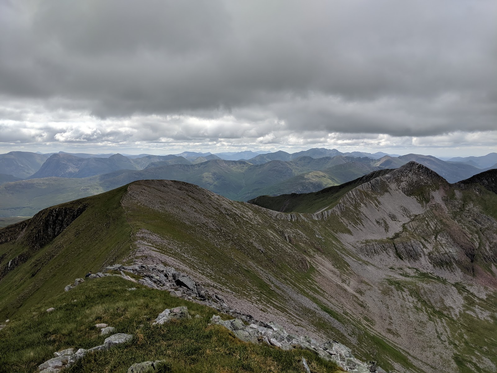
The vibes changed completely, on the ridgeline there was a cooler breeze and whilst it's not a knife-edge like Crib Goch, it is airy and in a magnificent setting. The views kept getting more spectacular as height was gained. Soon enough I reached a sharpening edge atop a vertical wall with an increasing drop to the left.  I had to descend off this to my right at the end which was quite thrilling what with the exposure, for me this was the most technical section of the day.

the narrow ridge atop the wall and the little descent section

looking back down the ridge and over to Carn Mor Dearg

I became increasingly apprehensive about this summit cloud...

I took my time and thoroughly enjoyed the scramble up The Ledge Route, which for the most part was steady and straightforward.  I topped out to magnificent views and enjoyed the steadier gradients as I bimbled around to the tourist / pony track, where the mood changed from 'alone' to 'surrounded by paradise'. Victory was in the air at the summit, which as I arrived was just clear of the cloud at least in a couple of directions.

the top of no. 5 Gully


Ben Nevis Summit

on top of the UK and inches below the clouds...

I felt quite slow going up the last stretch up to the summit. Effective oxygen at 4k ft is 17.9% compared to 20.9% at sea level, so whilst it's not the Himalaya and oxygen canisters are not necessary, I'm sure everything feels different up there.  I spent a while relaxing on the summit, exploring and taking in the sights and having a bite to eat.

Soon enough I started the long descent. Given that the previous day had been a big one I had made the management decision to head back down the pony track as opposed to carrying on round the CMD arete.
The trip down the tourist / pony track contrasted directly with the lonely, peaceful and technical route of ascent.  There was a steady flow of people going both directions, speaking all sorts of different languages. The path was a bit rough in places and the zig-zags felt interminable but soon enough I was peeling off towards Lochan Meall an t-Suidhe (or "Halfway Lochan" although it's not exactly halfway at c.570m) and away from the throngs again.


I took the wiggly path on the left which gives better views before rejoining the main drag
 
looking out Northwest over Glen Nevis
  
A good path peels off from the tourist track and heads out to the East end of the "Halfway Lochan" and it's outflow, which built in me a false sense of security that it might be plain sailing from here.  What followed was a hot and bothersome bog trot. If there is a path then I struggled to find it at the top end, towards the bottom section I wound up on more of a throughfare but it was't any great improvement as the ground was slippery and waterlogged underfoot.


Intake Eleven

After getting a bit hot and bothered with the conditions underfoot, I was grateful to reach Intake Eleven and the bridge just downstream where I rejoined the good path and retraced my route of ascent back down to the car, stopping to give directions to a family who had rented bicycles and become hopelessly lost in the woods.


I had a nice chat with a fella who had been up CMD, and we collectively pondered the wisdom of a mad lady who seemed to think she could get up and down in under 2 hours.

All that is left to do is come back in Winter Conditions for the CMD arete, if not the Ledge Route...

26 Aug 2019

A Weekend in Lochaber: Saturday 6th July 2019 - Binnein Mor

Saturday - Binnein Beag and Binnein Mor from Kinlochleven

Friday's forecast was utter dreich so I drove up at a leisurely place, checked into my accommodation, a lovely hobbit-esque glamping cabin at the consistently fantastic Blackwater Hostel in lovely Kinlochleven.  The rain cleared on Friday evening and I struck out at 8am on Saturday morning, eager to hit the hills.
I was in fact so eager that I walked 500m before realising I had forgotten my walking poles and had to pop back for them.
My delayed departure lead to me meeting a nice Scottish fella from Dundee who was heading the same way.  He talked with Scottish dialect, using great words like 'ken' and 'mind', and I think it's possible he struggled to understand my predominantly Yorkshire accent. His objective was Sgurr Eilde Mor before hitting the Binneins.  We chatted our way up the path from Kinlochleven via An Cumhann to the junction with the track at 390m where we parted ways. 

the views back from  An Cumhann toward Loch Leven

The path crossed a burn and pushed steadily upwards, soon enough I was traversing around the steep shoulder of Sgor Eilde Beag. I particularly love paths like this...

winding up along the steep shoulder of Sgor Eilde Beag

On rounding the corner the magnificent Coire an Lochain was revealed. The jeep track disappeared from view and I started to feel far away from civilisation as I pressed on into increasingly remote terrain.

Sgurr Eilde Mor looms above Coire an Lochain

looking down the valley from Coire an Bhinnein

I stopped to filter some water before following the path flanking the western slopes of Binnein Mor. I felt surrounded by nature alone, despite relative proximity to the bustle of Ben Nevis and Fort William, this is a fantastically remote area and I felt like I was in The Lord of The Rings.  The path lead to another magnificent lochan at the col between Binnein Beag and Binnein Mor. Whilst my objective was Binnein Mor, Binnein Beag looked so sweet and inviting I thought it would be a shame not to climb it first.

Binnein Mor viewed from the summit of Binnein Beag

As is typically the case, climbing up Binnein Beag wasn't quite as small of a matter as it had appeared from below. I topped out in due course to absolutely magnificent views all around before grabbing a bite to eat on the summit whilst trying to relate my route up Binnein Mor from the guidebooks to reality. The route on this forthcoming section had been a source of concern as the day had progressed.  A runner came up and tapped the cairn and put a split time on his watch before pulling a U-turn and trotting back down. There were a few runners in the vicinity, I expect some may have been attempting the Mamore Munro challenge which is an incredible feat!

looking back to Binnein Beag whilst gaining toward Garbh Coire
Whilst retracing my steps over the col I met my friend from earlier again, and he was making good progress, and shared some of my own concerns about the route of the impending approach to Binnein Mor.  He said one of the party a few hundred feet behind him had been up the North East Ridge before and it was 'great fun' which set my mind at rest somewhat.  I explained that I was going to try heading up into Garbh Corie before following the less steep slope up to the ridge. He looked puzzled. I pressed on pathless alongside a ravine and into the coire which was a beautiful place. I stopped to filter more water whilst becoming lunch for some of the resident midge.
The corrie provides good access for the Eastern ridge, but I was heading for the North East Ridge and the way up was a steady pathless clamber up boulders and big rocky scree. I reached the flat section of the ridge soon enough though and was rewarded with more magnificent views.

looking back from part way up the North-East Ridge of Binnein Mor

The next section up the ridge was an easy scramble, up and up I went and Binnein Beag started to appear quite small as I progressed to the high point for the day. The scramble gave a bit of good sport without feeling overly-committing and it offered choices of easier and harder lines. There were however some large and very precarious rocks which one could have toppled so it was important to take a precautious approach to every move.

Looking North from Binnein Mor. Left: The Ben with head in the clouds, right: Aonach Beag

I took great pleasure in topping off Binnein Mor, not least as I had started from within 10m of sea level and come such a roundabout way, but also because it is the highest point in The Mamores. The views were stunning.

Binnein Mor's short summit ridge

After a short break I cracked onward to the South Top and eventually Na Gruagaichean, via fantastic steady ridgelines which were a pleasure to bumble along whilst in such pleasant weather.

Looking back to Binnein Mor

Looking onward to Binnein Mor South Top with  Na Gruagaichean on the left

The Ben just about stayed in cloud the whole day

ideal ridge walking on the way to  Na Gruagaichean

Na Gruagaichean proved to be another fabulous viewpoint, and I stopped to chat with a group who had just come up the way I was headed down. There was talk of Hags and Groughs, which baffled me a little as I thought the path was meant to be a good one. The peak towers high over Kinlochleven, 1km above it in vertical terms. I adore the feeling of being high up and seeing places in miniature as if from a plane.

Kinlochleven was built for the Aluminium works and has an obvious 'new town' layout when viewed from above
Whilst the going was steep in places, I enjoyed making my way over the North-West subsidiary top of Na Gruagaichean and down to the baelach.  From here the end was well and truly in sight but I still had a lot of height to loose first.  I had gotten it into my head that there was a nice, reliable, well paved, easy track down from the col into Coire na Ba and thought it would be a breeze. Sadly it transpired I was thinking of the track down the next corie to the west.  By comparison with the day's walking thus far the boggy, meandering path to the corrie was unpleasant. To my disdain it started going uphill again before making a gigantic dog-leg. I meandered off course at a river crossing lower down. As I got lower the Summer Afternoon heat started to get to me too. First World problems...

looking North to Coire Ghabhail from the Baelach

My frustrations eased as the going started to improve, and I noticed how completely gorgeous Coire na Ba was becoming as I dropped into the treeline.

Coire na Ba

Soon enough the path joined a landrover track which led to Mamore Lodge, after which came the final steep descent through beautiful natural woodland via a path that was boggy in some places and very eroded in others; to emerge by The Grey Mare's Tail waterfall.

The abandoned Mamore Lodge hotel

all smiles

Truth be told I was pretty done-in by the time I rocked up at the hostel; I took a shower and had a restful evening to try and ready myself for the next day's adventure.

4 Mar 2019

Xmas Eve at the Top of England - 23rd and 24th December 2018

I didn't take any photos from the 23rd December. It was one of those where I made my plans up as I went along. I had intended to hike up towards High Raise from Grasmere and maybe camp at one of the tarns, but in the afternoon as I arrived at Grasmere it was raining steadily. I made a snap decision to drive on to Keswick in the hope of drier climes before turning back on myself and heading to Seathwaite, where I parked and made my way up Grains Gill towards Great End whilst the light dwindled.  I wound up camping at Esk Hause, as darkness and fog engulfed me it became nigh on impossible to navigate and I was glad to find a flat enough bit of ground there.
The night was cold but still, and by the morning of the 24th the cloud had lifted, I woke up to a world of wonderous views.

de-icing my cup in the morning

sadly Esk Pike blocked the best of the sunrise as I broke camp

Great End

Skiddaw on the horizon, Allen Crag on the right

The freezing fog gave everything a serious coating of frost

I used an accessory karabiner to try and scrape as much frost off the tent as possible before packing it up. This was painfully cold on the hands!


on my way to Scafell Pike, the top of England

It was exceptionally clear with far reaching views to the Isle of Man and Scotland

Scafell Pike trig with the Mosedale Round in the background

looking North

Great Gable dominating the foreground

What a fantastic day to visit Scafell Pike. The views were the clearest I have ever known up there and the wind wasn't bad at all. I spent a good while up there taking it all in and taking photos for a couple of passing parties.
The way down was one of my vary favourite routes and I took my time all the way savouring the views. I had a heavy old pack on and there was some veerglas on rocks which appeared dry. I slipped and hit the deck once but not too badly. It was one of those days where it was a sheer pleasure to be alive.

heading down The Corridor Route, which leads through a beautiful and other-worldly landscape


Piers Gill


Kirk Fell and Great Gable presiding over Wasdale


Sty Head Tarn and Seathwaite Fell

newly refurbished bridge

approaching Seathwaite

Hind Crag

on reaching my car in the afternoon it was still heavily frosted up

Suffice to say I drove home for Xmas in an excellent mood.